Produced by Stephen Hutcheson, Lisa Corcoran and the Online
Distributed Proofreading Team at http://www.pgdp.net
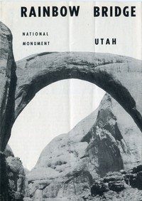
RAINBOW BRIDGE
NATIONAL MONUMENT
UTAH
[Illustration: DEPARTMENT OF THE INTERIOR · March 3, 1849]
UNITED STATES DEPARTMENT OF THE INTERIOR
Oscar L. Chapman, _Secretary_
NATIONAL PARK SERVICE
Arthur E. Demaray, _Director_
RAINBOW BRIDGE
NATIONAL MONUMENT
_Remote in spectacular red canyon country stands majestically
beautiful Rainbow Bridge, the most stupendous of its kind and one of
the great wonders of the world._
The inspiration gained by a visit to Rainbow Bridge National Monument is
supreme. The majestic beauty of the bridge affects people in many ways.
The delicate balance, graceful sweep, symmetry, beautiful toning of
color, and superb setting of this rainbow-shaped stone arch suggest
Divine guidance during its creation. The aborigines must have sensed
this, for they built altars here.
Rainbow Bridge stands in the semidesert country of southeastern Utah. It
nestles among canyons carved by streams that wind their way from the
northern side of Navajo Mountain toward the Colorado River. It spans
Rainbow Bridge Canyon and the tiny streamlet in its bottom.
Rainbow Bridge is greater than any other known natural bridge in size,
in color, and in its almost perfect symmetry. With a 278-foot span, the
bridge gracefully arches to a height of 309 feet—large enough to
straddle our capitol building in Washington, D. C. Thicker at the top
than a three-story building (42 feet), it is wide enough (33 feet) to
accommodate the average highway.
Rainbow Bridge stands in one of the most remote and inaccessible areas
in the United States. So rugged is the surrounding Rainbow Plateau that
few of the Navajo and Paiute Indians who live nearby have ever seen the
bridge.
_HISTORY OF DISCOVERY_
While leading an archeological expedition through southeastern Utah and
northern Arizona during the summer of 1908, Dr. Byron Cummings, then
Dean of Arts and Sciences, University of Utah, became interested in
rumors of a great stone arch somewhere in the vicinity of Navajo
Mountain. Mr. and Mrs. John Wetherill, of Oljato, Utah, related to him
rumors of the arch which were prevalent among the Indians. Mrs.
Wetherill later learned from Nasja, a Paiute Indian from Paiute Canyon,
that his son, Nasja-begay, had actually seen the great stone arch and
could return to it.
During July 1909, Dr. Cummings formulated plans to set out in search of
the bridge. There were delays in obtaining the necessary guides. In the
meantime, Dr. Cummings received word that W. B. Douglass, a Government
surveyor, was en route to the area also to look for the arch.
Subsequently, the Cummings-Douglass parties met and joined in the search
for the Nonnozoshi, which was the Navajo word for the great stone arch.
The journey lasted several days. The party crossed canyons and “slick
rock” surfaces where the horses slipped and skidded. Frequently, it was
necessary to retrace portions of the course, because forward progress
was blocked by “rimrock” ledges which the horses were unable to cross.
There were more canyons, some with dry, boulder-choked beds, others with
water and dense brush.
Across a scrub juniper (cedar) flat, and down into the last canyon they
went. This was Nonnezoshi Biko, the Indian guide’s name for the canyon
of the great stone arch, or Rainbow Bridge Canyon of the present.
The horses, as well as the men, were fagged because of the hard trail
and shortage of forage and water. The footsore procession trudged
forward; and in the late afternoon of August 14, 1909, the party rounded
a bend in the canyon, and Dr. Cummings became the first white man to see
the largest and most beautiful of all known stone arches, Rainbow
Bridge.
[Illustration: _How a natural bridge is formed_]
_HOW WAS IT FORMED?_
Geologists tell us that, at the time of the formation of the rocks from
which Rainbow Bridge was later carved, the physical environment of that
vicinity may not have differed greatly from much of the present
Southwest. Broad valleys surrounded by highlands were present.
Run-off from rainfall in the highlands brought great quantities of
gravel, sand, and mud, which were spread as horizontal sheets over the
floors of the valleys. Locally there were shallow lakes.
Mud and sand were deposited in the lakes, and evaporation of the water
produced limy and gypsum-filled muds. These sediments were compressed by
being deeply buried to form the layers belonging to the Kayenta
formation, part of which is the thin-bedded stratum exposed in the
canyon beneath Rainbow Bridge.
Following this period of deposition, there was a changed environment
during which sand accumulated until it was several hundred feet in
thickness. It was deposited in curved cross-bedded layers in dunes,
later to be blown away and redeposited again and again. This produced a
complex system of cross-bedding throughout the entire formation.
In time, a blanket of other rock materials was deposited by wind and
water over the shifting sand. Percolating water, with lime and gypsum in
solution, aided in making the material firm and hard to form what has
been named the Navajo sandstone.
Then followed a general uplift of the entire region. Drainage courses
traversed the newly formed rocks and the principal streams carved broad
valleys with sweeping curves or meanders. The wind and other forces of
weather chiseled away at the rocks to form “slick rock” surfaces and the
dome-shaped hills called whalebacks and baldheads.
A large mass of molten rock pushed outward from the interior, arching
the earth’s crust to form Navajo Mountain. This local uplift caused
small streams to furrow canyons across the soft cross-bedded Navajo
sandstone. It also caused the large streams to deepen their channels;
those with broad valleys, through necessity, followed the former
meandering course.
This frequently gave rise to blocks of solid rock, called “fins” and
“necks,” standing between entrenched meanders. It was one of these
“necks” from which Rainbow Bridge was formed.
When the “neck” was once formed, running water laden with cobbles and
sand scoured at the sides. Frost action and expansion and contraction,
due to temperature changes, loosened great slabs of rock as well as
particles. Gravity helped to remove them. Eventually, an opening was
worn through the “neck.” This gave the stream a direct course through
the “neck” rather than around it. Continuing erosion enlarged the
opening and deepened the gorge. Thus, the canyon spanned by Rainbow
Bridge came into being.
Mother Nature used the less severe forces of weathering for shaping and
polishing the outline of Rainbow Bridge. For example, when moisture
freezes within a crevice it exerts pressure on the surface of a rock and
causes the outer portion to shell off, forming a relatively smooth
surface. The Navajo sandstone is particularly subject to this type of
weathering. It is porous and the curved layers of the cross-beds are
held together with weak, natural cement that is easily removed by
percolating water.
Dissolving of the cementing materials and prying action by frost are the
chief agents for carving the rock. The cross-bedding is important in
controlling the shape. Thus, the combination of several factors, over a
long period of time, developed for us the arch as we now see it.
In the words of J. B. Priestly “How do we know that the Rainbow Bridge
is not itself a kind of symphony, no more to be completely explained by
geology than Beethoven is by acoustics?”
[Illustration: RAINBOW BRIDGE TRAIL FROM RAINBOW LODGE, ARIZONA, TO
RAINBOW BRIDGE NATIONAL MONUMENT, UTAH]
Horse and Foot Trail
RAINBOW BRIDGE NATIONAL MONUMENT EL. 3880′
Echo Spring Camp EL. 3860′
RAINBOW BRIDGE CANYON EL. 3840′
REDBUD PASS
SPRING EL. 4280′
CLIFF CANYON
EL. 6480′
EL. 6600′
Rainbow Lodge EL. 6280′
November 1950 RB-N.M. 7001
Vertical Cliff
Salmon pink is the predominant color of the sandstone from which the
arch is carved. This color is modified by streaks of red extending down
the sides of the structure. These stains are due to iron oxide, or
hematite, which is soluble in water. As rain fell on the upper part of
the arch, it dissolved some of the hematite and as the water moved down
the sides it dried, leaving streaks of variegated colors—mostly reds and
browns. The coloring becomes brilliant in the light of the late
afternoon sun. This is probably the basis for the Indian legends that
the arch is a rainbow changed to stone.
[Illustration: _The trail descends 2,000 feet into Cliff Canyon_]
_OTHER INTERESTING FEATURES_
Water dripping into the pools near the bottom of Rainbow Bridge Canyon
is from rain water that has seeped down through the Navajo sandstone.
When the water reaches impervious rock layers in the underlying Kayenta,
it is concentrated, but eventually it seeps out along the walls of the
canyon, forming springs.
Plants grow in profusion nearby. Maidenhair fern and wild orchids are
nestled in the shade. In addition, there are Indian paintbrush, loco,
lupines, daisies, asters, yucca, sunflowers, evening-primroses,
columbine, scarlet-bugler, and mariposa-lily.
_ESTABLISHMENT AND REGULATIONS_
Rainbow Bridge was proclaimed a national monument on May 30, 1910, by
President Taft. One hundred-sixty acres were placed under the protection
of the National Park Service. The monument is a sanctuary for all
wildlife, and hunting is prohibited. No plant life, other natural
features, or Indian artifacts may be gathered, cut, destroyed, or
removed from the monument. Visitors to the area are particularly advised
that the defacing of native sandstone with names or dates is vandalism
and that vandals will be prosecuted.
_HOW TO REACH RAINBOW BRIDGE_
The bridge may be approached from three directions: 1. From U. S. No. 89
to Tuba City, Tonalea, and then Rainbow Lodge, where mules are available
for the 14-mile trail trip. 2. From Mexican Hat by boat down the San
Juan and Colorado Rivers to Forbidden Canyon and 6 miles on foot to the
bridge. 3. From Lees Ferry 68 miles upstream by boat to Forbidden Canyon
and 6 miles on foot to the bridge.
Reservations for the boat trips should be made well in advance by
addressing J. Frank Wright, Mexican Hat Expedition, Blanding, Utah, or
Art Green, Soap Creek, Ariz., via Cameron, Ariz.
_FACILITIES_
Meals, lodging, guide service, and mules are available at Rainbow Lodge
from April 1 to November 15.
Campers in the area should provide themselves with gasoline, oil stoves,
or charcoal briquets. Firewood is not available, and the cutting of
trees, dead or alive, is prohibited. A small spring under the bridge
provides water for campers.
_ADMINISTRATION_
Rainbow Bridge National Monument is a part of the National Park System
administered by the National Park Service, United States Department of
the Interior.
There is no resident personnel at Rainbow Bridge. For information
relating to the monument write the Superintendent, Navajo National
Monument, Tonalea, Ariz., who is in direct charge of the area.
[Illustration: RAINBOW BRIDGE NATIONAL MONUMENT AND VICINITY]
RAINBOW BRIDGE NATIONAL MONUMENT
FORBIDDEN CANYON
PIUTE CANYON
Navajo Mountain Elev. 10,416′
RAINBOW LODGE
Dunn
Piute
NAVAJO NATIONAL MONUMENT
HEADQUARTERS AREA
INSCRIPTION HOUSE RUIN
INSCRIPTION HOUSE
BETATAKIN RUIN
KEET SEEL RUIN
MARSH PASS
_State Highway_ 47
Mexican Hat
Kayenta
To Bluff 20 Miles
_U. S._ 89
The Gap
Marble Canyon
Cameron
To Grand Canyon National Park North Rim 85 Miles
To Flagstaff 51 Miles
_State Highway_ 64
To Grand Canyon National Park South Rim 57 Miles
To Chinle 20 Miles (Approx.)
To Two Guns 75 Miles (U.S. 66)
To Holbrook 80 Miles
To Shiprock 105 Miles
COLORADO RIVER
Navajo Creek
NAVAJO CANYON
NAVAJO BRIDGE 467 FEET ABOVE COLORADO RIVER
GLEN CANYON
Lees Ferry
LITTLE COLORADO CANYON
San Juan River
MONUMENT VALLEY
Tyende Mesa
Agathia Peak 6,825
Chaistla Butte
Comb Ridge
HOPI INDIAN RESERVATION
NAVAJO INDIAN RESERVATION
ECHO CLIFFS
Dinnehotso
Rock Point
Kaibito
Mormon Ridge
Shonto Spring
Wildcat Peak
Rough Rock
Tonalea (Red Lake)
Tuba City
Zillesa Mesa
Moenkopi Plateau
November 1950 RB-N.M. 7000
Many of the roads in these reservations are not always passable.
Inquiry should be made before attempting a trip.
U. S. GOVERNMENT PRINTING OFFICE: 1951—O-939554
For sale by the Superintendent of Documents, U. S. Government Printing
Office
Washington 25, D. C.—Price $3.75 per 100
Transcriber’s Notes
—This eBook is based on a U.S. government publication which is public
domain in the United States.
—Corrected a few palpable typos.
—Within the map, transcribed labels, and added italicized text where
needed to define the context.
—In the text versions only, text in italics is delimited by
_underscores_.