Produced by Stephen Hutcheson, Lisa Corcoran and the Online
Distributed Proofreading Team at http://www.pgdp.net
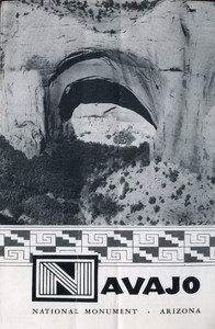
[Illustration: _Cover: Betatakin Ruin_]
[Illustration: Decorative title]
NAVAJO
NATIONAL MONUMENT · Arizona
United States Department of the Interior, Oscar L. Chapman,
_Secretary_
National Park Service, Arthur E. Demaray, _Director_
DEPARTMENT OF THE INTERIOR
March 3, 1849
_Perched high in their matchless settings, the three great cliff
dwellings of Navajo National Monument are the most striking remains of
ancient occupancy of the canyon country of northeastern Arizona._
From about A. D. 300 until about A. D. 1300 there lived in the San Juan
River drainage near the “Four Corners” of Colorado, Utah, New Mexico,
and Arizona, Indians we now call the Anasazi (a Navajo word which means
“The Ancient Ones”). Before A. D. 300 the Anasazi probably existed as
small bands who wandered over the colorful plateau country hunting and
trapping and gathering nuts and seeds; it is possible that they also did
a little haphazard farming.
About A. D. 300 farming became more important in their economy. With a
better and more dependable food supply population increased, people
began to be more sedentary, crafts improved, and more permanent homes
were built. By A. D. 1100 large villages of several hundred people each
had been developed, as well as many smaller communities.
As time passed, three cultural centers—really prehistoric tribes—had
differentiated from each other: the Chaco Canyon group, in northwestern
New Mexico; the Mesa Verde, in southwestern Colorado; and the Kayenta,
in northeastern Arizona.
The three cliff dwellings of Navajo National Monument represent this
third group. In these villages the culture of the Kayenta Anasazi
reached its peak and then deteriorated swiftly. A combination of
circumstances, chief of which probably were soil erosion caused by poor
agricultural practices and disease brought about by lack of sanitation,
resulted in a rapid loss of population. The remaining Anasazi abandoned
the Kayenta region shortly after A. D. 1300.
Betatakin, meaning “Hillside House,” is the most accessible ruin in the
monument. It is a well-preserved “apartment house,” 700 years old. As
determined by the tree-ring dating method, this ruin was occupied
between the years A. D. 1242 and approximately A. D. 1300.
Betatakin once had almost 150 rooms, of which more than 50 were
residential, 6 ceremonial (kivas), 13 open courts or patios, about 30
storage, and 2 grinding rooms. The last-mentioned are among the many
rooms which are still well-preserved.
Betatakin is built on the sloping floor of a great cave, carved by
stream meander and wind erosion in the side of a soft, red, sandstone
cliff which forms the sheer and vertical 500-foot north wall of a
picturesque and beautiful canyon. The cave roof projects far out over
the village. Sand storms had piled among the central rooms an
accumulation in which oaks 4 inches in diameter and varied shrubbery had
taken root.
[Illustration: _A portion of Betatakin Ruin_]
In the canyon fronting Betatakin are tall, slender quaking aspen;
boxelder, Douglas-fir, and pinyon deck the talus slopes; and juniper and
pinyon cap the bordering cliffs.
Betatakin was discovered in 1909 by Byron Cummings and the late John
Wetherill, and was excavated and stabilized in 1917 by Neil M. Judd, of
the Smithsonian Institution.
The pottery found in Betatakin and the other Segi cliff ruins is of
exceptional quality, artistically painted, and includes both
black-on-white ware and varieties of polychrome or “orangeware.”
_KEET SEEL_
Keet Seel is the largest cliff ruin in Arizona and one of the last to be
abandoned in the Segi Canyon region. It may be reached by horse or on
foot from Betatakin by an 11-mile trail, which is primitive and crosses
the canyon stream many times, making the trip on foot a difficult one.
Horses may be obtained from the nearby Navajos through the
superintendent of the monument. One full day is required for the round
trip.
Keet Seel was discovered in 1893 by Richard Wetherill. It was partially
excavated and stabilized in 1934, and today still gives the impression
that it might have been abandoned only a few years ago. Actually, almost
700 years have passed since the Anasazi last lived in this cliff city.
_INSCRIPTION HOUSE_
Inscription House lies almost 20 miles in an air line west of Betatakin,
the headquarters area. This fine ruin, the smallest of the three (with
approximately 75 rooms), was so named because of an inscription found
scratched into the plastered wall of one of the rooms. Weather-beaten,
little remains of the original inscription. It is generally believed to
be of Spanish origin and to date from the 1660’s, but the exact wording
has been variously reported. John Wetherill, from his second trip to
Inscription House in 1909, remembered the inscription thus:
C H O S
1661 A d n
with more letters which were illegible.
[Illustration: _Keet Seel Ruin_]
_THE MONUMENT_
Navajo National Monument was established by Presidential proclamation on
March 20, 1909, and contains 360 acres of federally owned land. It is
completely surrounded by the Navajo Indian Reservation and lies on the
edge of a “roadless area” nearly 100 miles from paved highways.
_RELATED AREAS_
Other cliff dwellings in the National Park System include those in
Canyon de Chelly, Walnut Canyon, Montezuma Castle, and Tonto National
Monuments in Arizona; Mesa Verde National Park in Colorado; and
Bandelier and Gila Cliff Dwellings National Monuments in New Mexico.
_ACCOMMODATIONS AND SERVICE TO THE PUBLIC_
Only designated campgrounds and picnic benches are available in the
monument, but trading posts and guest ranches in Kayenta, Tonalea,
Goulding, Tuba City, Shonto, and Rainbow Lodge offer modern
accommodations.
Because of the need of protecting the ruins, and the difficult unmarked
trails by which they are reached, no one is allowed to enter any ruin
unless accompanied by a guide.
Betatakin may be viewed from the binocular station on Betatakin Point at
any time, with or without a guide.
[Illustration: _Inscription House Ruin_]
Trips to Betatakin should start at 9 a.m. or 1 p.m.; and to Keet Seel at
8 a.m.
_ADMINISTRATION_
Navajo National Monument is a part of the National Park System
administered by the National Park Service, United States Department of
the Interior. The Superintendent, Navajo National Monument, is in
immediate charge and inquiries regarding the monument should be
addressed to him at Tonalea, Ariz.
Monument headquarters are located near Betatakin, and visitors to
outlying areas may obtain information and guidance by calling there
first.
[Illustration: NAVAJO NATIONAL MONUMENT AND VICINITY
MANY OF THE ROADS IN THESE RESERVATIONS ARE NOT ALWAYS PASSABLE.
INQUIRY SHOULD BE MADE BEFORE ATTEMPTING A TRIP.]
NAVAJO NATIONAL MONUMENT
INSCRIPTION HOUSE RUIN
KEET SEEL RUIN
BETATAKIN RUIN
HDQRS. AREA
_Other Parks and Monuments_
PETRIFIED FOREST NAT. MON.
PAINTED DESERT
_Highway_ 65
RAINBOW BRIDGE NAT. MON.
Navajo Mtn. 10,416
SUNSET CRATER NAT. MON.
WALNUT CANYON NAT. MON.
WUPATKI NAT. MON.
Humphreys Peak 12,611
To Arches Nat. Mon. 166 miles
_Highway_ 47
To Grand Canyon N. P. 56 Miles
_Highway_ 64
To North Rim Grand Canyon 85 miles
_U.S. Highway_ 89
To Tonto Nat. Mon. 133 Miles
_Highway_ 65
To Tuzigoot Nat. Mon. 52 Miles
_U.S. Highway_ 89A
Marble Canyon
NAVAJO BRIDGE 467 Feet ABOVE COLORADO RIVER
WESTERN NAVAJO INDIAN RESERVATION
Cameron
Cow Spring
Echo Cliffs
Kayenta
Rainbow Lodge
Shonto
Tonalea
Tuba City
To Shiprock 105 Miles
Agathla Peak 6,825
Comb Ridge
Marsh Pass
Monument Pass
NAVAJO INDIAN RESERVATION
Indian Wells
Leupp
Sunrise
HOPI INDIAN RESERVATION
Keams Canyon
Oraibi
UTAH
Goulding
ARIZONA
Flagstaff
Holbrook
Lees Ferry
Two Guns
Winslow
To Gallup 73 Miles
To Globe 138 Miles
_Highway_ 77
To Pine 80 Miles
To St. John 43 Miles
_U.S. Highway_ 260
To Williams 32 Miles
_U.S. Highway_ 66
_Drainage_
Colorado River
Navajo Creek
Little Colorado River
LITTLE COLORADO CANYON
DOT KLISH CANYON
Dinnebito Wash
Oraibi Wash
Polacco Wash
Beshbito Wash
Leroux Wash
Laguna Cr.
February 1951 Sept. 1946 N. M. Nav. 7000
Revised 1951 U. S. GOVERNMENT PRINTING OFFICE : 1951-O-939166
For sale by the Superintendent of Documents, U. S. Government Printing
Office
Washington 25, D. C.—Price $3.75 per 100 copies
Transcriber’s Notes
—This eBook is based on a U.S. government publication which is public
domain in the United States.
—Corrected a few palpable typos.
—Within the map, transcribed labels, and added italicized text where
needed to define the context.
—In the text versions only, text in italics is delimited by
_underscores_.