Produced by Stephen Hutcheson, Lisa Corcoran and the Online
Distributed Proofreading Team at http://www.pgdp.net
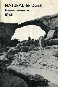
[Illustration: Cover: _Owachomo Bridge._]
[Illustration: Natural Bridges National Monument]
Natural Bridges
NATIONAL MONUMENT · UTAH
[Illustration: UNITED STATES DEPARTMENT OF THE INTERIOR · NATIONAL
PARK SERVICE]
UNITED STATES DEPARTMENT OF THE INTERIOR
Douglas McKay, _Secretary_
NATIONAL PARK SERVICE, Conrad L. Wirth, _Director_
_Three gigantic natural bridges carved out of sandstone and located in
a region of superb scenery_
San Juan County, in the southeastern corner of Utah, is a land of
brilliantly colored cliffs, tortuous box canyons, pinnacles, and arches.
Near the center of this scenic and geologic potpourri is Natural Bridges
National Monument.
Within the monument are three huge natural bridges. While they are
exceeded in size by the great Rainbow Bridge, which lies about 60 miles
to the southwest in Rainbow Bridge National Monument, they rank with the
largest known natural bridges.
One of these bridges--Owachomo--is directly across the 600-foot-deep
Armstrong Canyon and spans the mouth of a short tributary canyon. The
road from Blanding, Utah, ends at the rim of the Armstrong Canyon. To
visit the other bridges in the monument, one must walk. The trail is
unimproved, and sometimes rough, but the 6-mile hike is rewarded by
views of the magnificent canyons, the bridges, and ancient Indian ruins.
The headquarters area of the monument overlooks the Owachomo Bridge, and
a 300-yard trail drops to the bottom of Armstrong Canyon to a point
where one can walk under the bridge. Continuing on this trail, Sipapu
Bridge may be reached by a 3-mile walk; however, if you wish to see all
three bridges with the least walking, drive your car from headquarters,
4½ miles, to the Kachina Bridge parking area and from there it is
three-quarters of a mile by a ladder trail to Kachina Bridge and 2 miles
from Kachina to Sipapu Bridge, up White Canyon. No trail is maintained
between Kachina Bridge and Owachomo Bridge.
The Bridges and Their Names
The bridges were first seen by white man in 1883 when Cass Hite, a
prospector, visited the region. National publicity was given to the area
in 1904 when an illustrated article appeared in the National Geographic
Magazine. In 1908 the area was proclaimed Natural Bridges National
Monument by President Theodore Roosevelt. This action was the result of
pleas of Utah citizens and of a Government surveyor that the bridges be
protected by the Federal Government.
[Illustration: _Owachomo is in view at the end of the road._]
Early explorers had named the bridges for members of their parties or
for relatives. When the monument was established, an effort was made to
find Indian names which would fit the bridges. Paiute Indians, who still
live in the country, had no names for the individual bridges. At the
time they were questioned they professed to know only a single term
which they applied to all bridges, natural or otherwise. This was
"Ma-Vah-Talk-Tump," or "Under the Horse's Belly."
[Illustration: _Kachina Bridge--the youngest of the three._]
At that time it was generally thought that the prehistoric people who
had lived in the ruins of southern Utah were direct ancestors of the
Hopi Indians, so it was natural, when no Paiute names were forthcoming,
that Hopi names were applied to the bridges. They are:
_Owachomo_ (Rock Mound)--So named because of a large, rounded block of
rock on the mesa near one end of the bridge. Also formerly known as the
Edwin Bridge.
_Kachina_--On one of the abutments of this bridge are numerous
prehistoric pictographs, some of which resemble Hopi masked dancers, or
kachinas. The former name for this bridge was Caroline.
_Sipapu_--The graceful arch of this bridge suggested to its namers the
sipapu (place of emergence), a hole through which the Hopi believe their
ancestors emerged from a lower, dark world into the present, sunlit one.
This was also known as the Augusta Bridge.
The dimensions of the bridges are:
Bridge Height (feet) Span (feet) Width (feet) Thickness (feet)
Owachomo 106 180 27 9
Kachina 210 206 44 93
Sipapu 220 268 31 53
How Natural Bridges Are Made
To make a natural bridge Mother Nature must have several ingredients: a
proper stone that will shape well (a cross-bedded sandstone is best), a
slowly rising landscape, and a desert-type stream that occasionally will
scour its bed with a tremendous head of water and sand. All these were
present in southern Utah.
The stone of the Natural Bridges area is a cross-bedded grey sandstone,
known as the Cedar Mesa sandstone. It is of Permian age and similar in
appearance and structure to the more recent Navajo sandstone in which so
many caves and arches have been formed.
When the land began to rise slowly from its ancient sea bed, two small
streams formed on the western slopes of the Elk Ridge. The streams are
known today as White River and Armstrong Creek, its tributary. They made
meandering channels across the flat land and gradually entrenched
themselves into tortuous canyons. As the land continued to rise, the
streams cut ever deeper canyons.
The main purpose, or the driving force, of a stream is to make the
shortest distance between two points, that is, a straight line. Every
creek and river attempts to make a straight channel with an even grade
from its source to its mouth. Hills, ridges, blocks of rock, or any
other obstacles which a stream must bypass are gradually worn away as
the stream makes a channel more to its choice.
The tortuous streams in their deep rock channels were constantly trying
to straighten their courses. During floods the silt-laden waters were
thrown with great force against the walls of the meanders. In several
places the fins of rock around which the windings of the streams passed
were so thin that during the course of many centuries of buffeting the
rock gradually wore away and a hole was bored through the fin. The
waters poured through the gap and the bridge was born. After the initial
breach was made, the stream continued to enlarge the opening and to cut
its channel still deeper. Eventually, the old meander was left high and
dry as a "fossil" stream bed.
Ages of the Bridges
Several phases of bridge-making may be seen at Natural Bridges National
Monument.
Kachina Bridge is a new bridge. It is huge and bulky, and has a
comparatively small opening. White River is still actively enlarging the
opening beneath the span.
Sipapu Bridge is mature. It is a graceful, symmetrical span, and its
abutments now lie far enough from the stream bed that the river has
little or no cutting action on the rock.
[Illustration: _Sipapu Bridge, looking up White Canyon._]
Owachomo Bridge is in its old age. It suffers no erosion from the
stream; only the slight erosion from rains, frost action, or wind-blown
sands now attack its surface. The life expectancy of Owachomo is short
compared with that of the other two; it may span the canyon for
centuries yet, or the crack which will ultimately cause its collapse may
already have started.
The fate of all the bridges may be seen a short distance up White Canyon
from Sipapu Bridge where faint scars and damaged abutments on the canyon
walls indicate the point where a fourth bridge once spanned the canyon.
Comparison With Other Types of Natural Bridges
Most of the natural bridges of the United States are in the Four Corners
region of the Southwest where favorable materials and conditions for
bridge-making are to be found. There are two other types of bridges
which are entirely dissimilar. Tonto Natural Bridge, in central Arizona,
is a "built-up" bridge created by travertine deposited by springs.
Natural Bridge, in Virginia--another well-known bridge--apparently was
formed when most of the roof of a cavern collapsed.
Wildlife
Deer are numerous in the pinyon and juniper forest which surrounds the
monument, and mountain sheep, which spend their summers on the Elk
Ridge, winter in the canyons. Smaller mammals are numerous, as are the
coyotes and wildcats. An occasional lion works through the monument.
Archeology
This section of Utah supported an Indian population from about 2,000
years ago until about A. D. 1300. Thousands of ruins stud the mesas and
canyons of the district. Comparatively few sites lie within the
monument, however, for both White and Armstrong Canyons are too narrow
to have furnished enough farming land for more than a few families.
Visitors who hike around the trail to the bridges may see one cliff
dwelling of about 20 rooms and several small rooms (apparently
granaries) which were built on ledges high on the cliffs. An outstanding
feature of the cliff dwelling is a kiva, or ceremonial room, with the
original roof and ladder intact. The people who lived here during
prehistoric times were closely related to those who lived on the Mesa
Verde in southwestern Colorado.
Caution
The two approach roads serving Natural Bridges National Monument from
Blanding, Utah, are unsurfaced dirt roads with steep grades. During
heavy rain storms they become either difficult or impassable to travel.
The upper road over Bear's Ears Pass (elevation 9,000 feet) is usually
blocked by snow and impassable from late September until late May. The
lower road, via Comb Wash, stays below 7,000 feet and is usually open
most of the year.
There are no accommodations for travelers beyond Blanding. Visitors
should make certain that they have ample food before they leave
Blanding. There is camping space at the monument for those who have
bedding and cooking equipment. A National Park Service ranger is
stationed at the monument only during the summer.
Administration
Natural Bridges National Monument, with an area of 2,649.70 acres, is
administered by the National Park Service, United States Department of
the Interior. Communications regarding the monument should be addressed
to the Superintendent, Arches National Monument, Moab, Utah.
_The National Park System, of which Natural Bridges National Monument
is a unit, is dedicated
to the conservation of America's scenic, scientific, and historic
heritage for the benefit and
enjoyment of the people._
[Illustration: NATURAL BRIDGES NATIONAL MONUMENT
UTAH]
SIPAPU BRIDGE
TRAIL
KACHINA BRIDGE
PARKING
OWACHOMO BRIDGE
RANGER STATION
(Extremely Rough Road)
TO HITE 48 MILES
TO BLANDING 50 MILES
ARMSTRONG CANYON
WHITE CANYON
May 1950 NM-N.B. 7000
REVISED 1954
U. S. GOVERNMENT PRINTING OFFICE: 1954 O-F--301544
Transcriber's Notes
--This eBook is based on a U.S. government publication which is public
domain in the United States.
--Corrected a few palpable typos.
--Within the map, transcribed labels, and added italicized text where
needed to define the context.
--In the text versions only, text in italics is delimited by
_underscores_.