Produced by Stephen Hutcheson and the Online Distributed
Proofreading Team at http://www.pgdp.net
U.S. DEPARTMENT OF THE INTERIOR, STEWART L. UDALL, Secretary
Bureau of Reclamation, Floyd E. Dominy, Commissioner
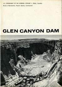
GLEN CANYON DAM
PHYSICAL DATA--GLEN CANYON STORAGE UNIT
DAM
Type: Concrete arch.
Height above river bed _ft._ 580
Height above lowest _ft._ 710
point in foundation
Crest length _ft._ 1,500
Crest width _ft._ 25
Base width _ft._ 340
Concrete _cu. 4,830,000
yds._
(dam)
(powerplant) 275,000
There are 3¼ million cu. yds. in Hoover Dam, and 10½
million in Grand Coulee.
Crest elevation _ft._ 3,715
Maximum discharge _sec. ft._ 276,000
through spillways
RESERVOIR
Capacity. _ac. ft._ 28,040,000
Area _acres_ 162,700
Elevation reservoir _ft._ 3,700
water surface
The river elevation at
Glen Canyon is 3,142 ft.
Length. _miles_ 186
POWERPLANT
Capacity _kw._ 900,000
Number of units 8
Capacity of each _kw._ 112,500
generator.
Capacity of each turbine _hp._ 155,500
[Illustration: THE PROJECT AND THE DAM]
GLEN CANYON
FLORIDA
PINE RIVER EXT
NAVAJO
HAMMOND
LA BARGE
SEEDSKADEE
LYMAN
FLAMING GORGE
CENTRAL UTAH
EMERY COUNTY
SILT
PAONIA
SMITH FORK
CURECANTI
The Glen Canyon Dam, Powerplant, and Reservoir, which will be known as
Lake Powell in honor of the western explorer and geologist, John Wesley
Powell, are the principal storage and power features of the Upper
Colorado River Storage project. The dam will be on the Colorado River in
Arizona, 13 river miles below the Utah border. Lake Powell will store
about 28,000,000 acre feet of water--next in size to Lake Mead,
downstream, America's largest man-made lake--to help solve a water
resource development problem in the Colorado River Basin.
The crux of the problem is the division of the river's water between the
Upper and Lower Basins of the Colorado River, as provided by an
interstate compact. The volume of water flowing down the Colorado
fluctuates sharply from year to year. Consequently, there must be
long-term holdover storage capacity in order to meet downstream needs
and compact requirements--including requirements for Mexico under an
international treaty--and still permit the Upper Basin States to deplete
the river for upstream use.
This problem will be solved by construction of a system of storage dams
and reservoirs in the Upper Basin, of which Glen Canyon, the largest, is
one of four initial units authorized. Only 15 miles above the dividing
line between the Upper and Lower Basins, it will store no water for use
upstream or in the immediate vicinity of the dam, but is the principal
unit storing water to regulate the river and thereby fulfill compact
commitments to the Lower Basin. The sale of hydroelectric energy
generated at the multipurpose dams will return practically all of the
cost of the project and a large part of the cost of 11 participating
irrigation projects authorized for initial Upper Basin development.
That, in general, is how Glen Canyon Dam on the Colorado and three other
initial dams on its tributaries will aid in developing the area. The
participating projects just referred to, and scattered throughout the
Upper Basin (11 of them authorized for construction), will irrigate
about 130,000 acres in new farms and improve irrigation on about 230,000
acres in old ones. Some 25 other projects are under various phases of
study. Farming, in consequence, will greatly increase. Water from the 4
big storage reservoirs will, as planned, turn generators of about
1,200,000-kilowatt capacity, and industry will use the power. Mineral
deposits of inestimable value, uranium among them, will be mined. Flood
control and navigation on the Colorado will be improved, and the
nation's playgrounds will be greatly enlarged, for some of the world's
finest recreation places will lie along the shores of the reservoirs or
lakes that will form behind the dams.
Glen Canyon Storage Unit will be the keystone in this whole structure.
The dam spans the river near its exit from the Upper Basin, as if in the
spout of a great funnel where it can control all of the water in the
funnel's cone--the Colorado's own flow and all that its tributaries feed
into it upstream from the dam. The powerplant will generate about 75
percent of the project's total power and the reservoir will contribute
about 75 percent of the water storage that the Congress authorized in
1956 as initial development for the Upper Basin. This reservoir or lake,
extending 186 miles behind the dam, will be flanked by remarkably
beautiful scenery. The Nation's gain in new public and private wealth
will be tremendous.
The Federal Government will finance the project, but the people who use
the water and power will repay about 99 percent of the cost--about
two-thirds with interest.
BRIDGE AT THE DAMSITE
[Illustration: Bridge]
Bridges were among the first essentials at Glen Canyon damsite. The
vertical walls of the Canyon rise about 700 feet above the river. The
distance from rim to rim is only 1,200 feet in a straight line, but it
is about 190 miles by road.
The Glen Canyon Bridge, a spectacular rim-to-rim highway, spans the
canyon immediately downstream from the dam. It is the highest and
second-longest steel arch bridge in the United States; its 1,028 foot
arch stands 700 feet above the river. The deck is 1,271 feet long. The
roadway is 30 feet wide and is paralleled by 4-foot sidewalks. The
bridge was dedicated and opened to public use on February 20, 1959.
Materials and equipment are transported to the canyon floor by
highlines--heavy cableways stretched between towers, two on each rim.
Loads of 50 tons are lowered from them on pendant hooks.
CONSTRUCTION
[Illustration: Construction in progress]
Glen Canyon Dam, like all large Reclamation dams, is being built by
private construction companies that are awarded contracts by competitive
bidding. The prime contract, totaling $107,955,122, was awarded to the
Merritt-Chapman and Scott Corporation of New York City, April 29, 1957.
It provides for construction of the dam and powerhouse and is the
largest single contract the Bureau has ever awarded and probably the
largest for any type of construction project.
By June 1960, the contractor had completed the diversion and spillway
tunnels, lined them with concrete, built the coffer dams (temporary
earth structures diverting the river around the damsite during
construction), and excavated the foundation of the dam. First placement
of concrete in the foundation of the dam and powerhouse was observed by
public ceremonies at the damsite on June 17, 1960. Initial storage of
water behind the dam is scheduled for early 1962.
A $6,392,000 contract for the manufacture of eight 155,500-horsepower,
150-r.p.m., vertical-shaft hydraulic turbines for the powerplant has
been awarded to the Baldwin-Lima Hamilton Corp. Additional contracts for
generators and other adjuncts will be awarded later to equip the dam and
powerplant. Glen Canyon's first hydroelectric generating unit is
scheduled to go on line in 1964.
RECREATION PLANS
[Illustration: Water recreation]
The Glen Canyon of the Colorado River is an unusually placid, 162-mile
reach from Hite, Utah, to Lees Ferry, Arizona. Major John Wesley Powell,
who headed the first expedition down the river in 1869, named it Glen
Canyon because of the occasional oak glens along its banks and at its
junctions with tributaries.
The 186-mile-long Glen Canyon Reservoir (Lake Powell) will extend
upstream into Cataract Canyon. The lake and adjoining lands have been
established as the Glen Canyon National Recreation Area under the
National Park Service of the Department of the Interior. This is the
status of Lake Mead and its environs behind Hoover Dam.
The Park Service will soon undertake construction of recreational
facilities for public use as Lake Powell begins to fill in 1962. The
Glen Canyon Recreation Area promises to become one of the Nation's
outstanding tourist attractions.
[Illustration: _Lake Powell, behind Glen Canyon Dam, will be flanked
by varied and beautiful scenery._]
[Illustration: _The first placement of concrete--June 17, 1960._]
[Illustration: Aerial view of dam and town]
HIGHWAYS TO GLEN CANYON DAM.--Excellent, new, paved highways have been
built to the Glen Canyon damsite. A 76-mile highway through the highly
scenic area has been built from Kanab, Utah, to the damsite. A new
25-mile highway extends northward from Bitter Springs to the damsite.
Both of these highway links connect with the Glen Canyon Bridge to form
a new link in U.S. Highway 89. The Glen Canyon Bridge was completed in
February 1959.
DISTANCES TO GLEN CANYON FROM:
Kanab, Utah 76 miles
Flagstaff, Arizona 135 miles
(Flagstaff and Marysvale, Utah, 190 miles from the
damsite, are nearest railheads.)
Cedar City, Utah 161 miles
Phoenix, Arizona 300 miles
Salt Lake City, Utah 384 miles
National Parks:
Zion 100 miles
Bryce 138 miles
Grand Canyon, North Rim 124 miles
Grand Canyon, South Rim 142 miles
· _Two 16 mm. color, sound films_, Canyon Conquest _and_ Key to the
Future, _are available upon request for showing to school and civic
groups, clubs, and other public gatherings. Both films show men and
machines at work on this challenging Reclamation project. Send your
requests to: U.S. Department of the Interior, Bureau of Reclamation,
P.O. Box 360, Salt Lake City 10, Utah. Eastern area residents may
write to the U.S. Department of the Interior, Bureau of Reclamation,
Washington 25, D.C._
_[1961--REVISED]_
U.S. GOVERNMENT PRINTING OFFICE: 1960 OF--574577
QUESTIONS AND ANSWERS
GLEN CANYON DAM
U. S. DEPARTMENT OF THE INTERIOR, STUART L. UDALL, SECRETARY
BUREAU OF RECLAMATION, FLOYD E. DOMINY, COMMISSIONER
THE DAM
HISTORY
Q. When was Glen Canyon investigated as a potential damsite?
A. First in 1921, then again in 1946 and in subsequent years.
Q. When was Glen Canyon Dam authorized for construction?
A. April 11, 1956, as part of the Colorado River Storage Project.
Q. When did work actually begin?
A. The first blast was detonated on October 15, 1956.
COMPLETION SCHEDULES
Q. When is the dam scheduled to be finished?
A. Construction of the dam and powerplant is scheduled for
completion in March 1964.
Q. When is the first power scheduled to be generated?
A. The first power should go on the line in the spring of 1964.
EXCAVATION
COFFER DAMS
Q. What are the coffer dams?
A. Large, temporary earth dams across the floor of the canyon and
located upstream and downstream from the foundation and keyway
areas which mark the axis of the dam.
Q. Why are coffer dams built?
A. To divert the Colorado River around the damsite through huge
diversion tunnels and to keep water out of the work areas
during construction of the dam and powerplant. The deepest
excavation to bedrock in the dam foundation is 137 feet below
the former river level.
DIVERSION TUNNELS
Length (West) 2,749 feet
Length (East) 3,011 feet
Diameter (lined) of both tunnels 41 feet
Q. Why does the west diversion tunnel carry the most water?
A. Because the intake of the west tunnel is 34 feet lower than the
intake of the east tunnel.
SPILLWAYS
Q. Where are the spillway intakes located?
A. They are just upstream from the keyways, one on each rim of the
canyon.
Q. Where will the spillways discharge?
A. Steep, inclined tunnels will extend from the spillway intakes to
intersect with the diversion tunnels far below. Thus, water
going through the spillways will emerge from the diversion
tunnels as the river water now does.
Q. What is the maximum combined capacity of the two spillways?
A. 276,000 cubic feet per second.
POWERPLANT
Q. Where will the powerplant be located?
A. On the upstream side of the Glen Canyon Bridge just below the dam.
The powerhouse will extend across the canyon floor parallel to
the bridge.
Q. How large will the powerplant be?
A. The powerhouse structure will be about 665 feet long and about 160
feet, or 16 stories high, above the downstream river level.
Eight generating units will be installed. The rated capacity
will be 900,000 kw for the powerplant.
Q. What are the square columns between the dam and the powerplant?
A. These huge concrete piers will support the 15-foot diameter
penstock pipes which will carry water from the reservoir
through the dam and into the turbines in the powerplant.
GENERAL
Q. What are the numerous black spots above the tunnel portals and
elsewhere?
A. These are 8-inch square metal plates on the ends of anchor bolts.
The anchor bolts extend into the rock to support the relatively
thin outer layers of rock.
Q. What are the white markings on the canyon walls?
A. Survey control or reference points which have been painted on the
rock.
Q. Why was the small suspension footbridge built?
A. More than 2 years was required to build the Glen Canyon
Bridge--the highest steel-arch bridge in the world. Therefore,
the footbridge was built so workers could cross the 1200-foot
wide canyon; otherwise, it was 200 miles around by road.
CONCRETE PLACEMENT
GENERAL
Q. How much concrete will the dam contain?
A. There will be more than 5,000,000 cubic yards of mass concrete in
the dam, and about 400,000 additional cubic yards in the
powerhouse, tunnels, and other structures at the damsite.
AGGREGATE (Sand and gravel for the concrete)
Q. Where does the aggregate used to make concrete come from?
A. From the streambed of Wahweap Creek, 6 miles from the damsite.
Q. Is there a conveyor belt from the aggregate plant to the damsite?
A. No. The aggregate is hauled in large bottom-dump trucks.
CEMENT
Q. How much cement will be needed?
A. Approximately 3 million barrels, or 12,000,000 sacks.
Q. Where does the cement come from?
A. From a new cement plant constructed by the American Cement
Corporation near Clarkdale, Arizona, 188 miles south of the
damsite.
POZZOLAN
Q. What is pozzolan?
A. Pozzolan is a cement-like material which occurs in natural
deposits.
Q. Why is pozzolan used?
A. Pozzolan is cheaper than cement; it reduces shrinkage in concrete
and develops less heat in concrete during the curing period.
Q. Where is it obtained?
A. Near Flagstaff, Arizona, about 115 miles from the damsite. About
220,000 tons will be used along with 564,000 tons (3,000,000
barrels) of cement.
CONCRETE MIXING PLANT
Q. What is capacity of the mixing plant?
A. The maximum capacity is 480 cubic yards per hour, which is mixed
in six, 4-cubic yard concrete mixers.
Q. How large is the mixing plant?
A. It is 217 feet, or more than 20 stories, in height.
HIGHLINE CABLEWAYS
Q. What will the highlines do?
A. Their main function is to carry the buckets of concrete from the
batch plant to points of placement in the dam and powerplant.
Q. What is the size and weight of the concrete buckets?
A. 12 cubic yards. When filled, the buckets weigh 31 tons, 24 tons of
which is the concrete carried in the buckets.
Q. How large are the highlines?
A. The higher towers are 190 feet tall; the main cable is 4 inches in
diameter and about 2,000 feet long.
REFRIGERATION PLANT
Q. Why is the refrigeration plant necessary?
A. A large amount of heat is produced by the chemical action of
cement during the setting of the concrete. The heat must be
removed to prevent expansion and cracking of the concrete. The
refrigeration plant supplies the slush ice and cold water
necessary to reduce this heat.
Q. How is the heat controlled?
A. First, the aggregate is sprayed with ice water before going into
the mixers. Second, slush ice, along with water, is used in
mixing the concrete. Third, cold water is pumped through pipes
embedded in the concrete to carry away the heat generated.
Q. How long will cold water have to be pumped through the cooling
tubes in the dam?
A. Approximately 12 days immediately following placement of the
concrete to prevent uncontrolled cracking. Then for about 52
days in the second stage, which may be many months later and
which is for the purpose of assuring uniform shrinking of the
huge concrete blocks.
CONCRETE BLOCKS
Q. How large are the blocks of concrete placed in the dam?
A. They vary in size. The largest are 70 feet by 180 feet in area;
all blocks will be 7½ feet thick.
Q. Why are blocks used rather than building the dam as one solid
piece?
A. Primarily, block placement facilitates cooling of the concrete and
controls cracking due to contraction of the concrete. After the
blocks have set and cooled, a mixture of cement and water
(called grout) is pumped under high pressure into cracks
between the blocks to form one solid mass of concrete.
PAGE, ARIZONA
GENERAL
Q. After whom was the town of Page named?
A. The late John C. Page, who served as Commissioner, Bureau of
Reclamation, from 1937 to 1943.
Q. Was there a community on the site of Page prior to 1957?
A. No, nothing but raw desert land like that now surrounding the
community.
CLIMATE
Q. What is the elevation of Page?
A. 4300 feet, or about 500 feet higher than the rim of the canyon.
Q. What are the extremes of temperature in Page?
A. 105 degrees in summer; 10 degrees in winter.
ACCOMMODATIONS
Q. Does Page have overnight accommodations?
A. Yes, two modern motels are open year around.
Q. Are there any restaurants?
A. Yes, there are now four restaurants in Page. In addition, the
contractor's mess hall is open to the public.
DPS, Utah General Depot, 5-61, 100M
Transcriber's Notes
--Silently corrected a few typos.
--Retained publication information from the printed edition: this eBook
is public-domain in the country of publication.
--In the text versions only, text in italics is delimited by
_underscores_.
--Transcribed or tabulated some text within illustrations.